Rent a car in Natakhtari with flexible pickup options. Affordable prices, reliable service, and a variety of vehicles to choose from. Book now online
Book Now From Car Rental Natakhtari – Pickup at the Airfield
- Pick-Up: 30 USD
- Return: 30 USD
- Early Pick-Up: 30 USD
- Late Return: 30 USD
- Mondays: 08:00 - 20:00
- Tuesdays: 08:00 - 20:00
- Wednesdays: 08:00 - 20:00
- Thursdays: 08:00 - 20:00
- Fridays: 08:00 - 20:00
- Saturdays: 08:00 - 20:00
- Sundays: 08:00 - 20:00
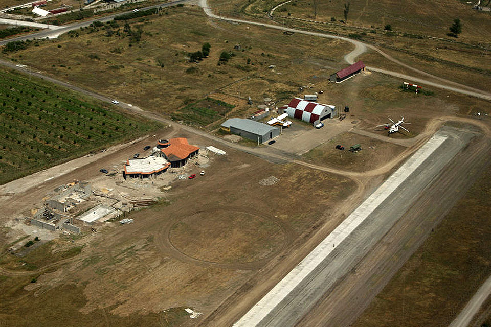
Where Is Natakhtari Airfield and Why Should You Start There?
Natakhtari Airfield is a small, regional airstrip about 30 minutes north of Tbilisi. It’s known for its scenic setting and relaxed vibe, far from the traffic and pressure of the capital. Whether you’re arriving by private flight or simply looking for an alternative pickup point, this spot offers a smooth start to your road trip.

Personally, I think Natakhtari feels more like a countryside café than an airfield. You can grab a coffee while waiting for your car – no queues, no stress. That’s part of the charm.
Rent a Car Natakhtari Airfield – Any Place Pickup
At carsandrooms.ge, we know that flexibility matters. That’s why our Car Rental Natakhtari service includes a handy “Any Place Pickup” feature. Staying in Saguramo? We’ll bring the car to your guesthouse. Flying into the airfield? We’ll meet you on the runway. Just let us know where you want the keys handed over – we’ll make it happen.
Local Drivers Love the Freedom Too
Sometimes locals ask us for rentals at Natakhtari to avoid going into town. It saves time, especially if you’re planning a quick weekend escape. And yes – we’ve dropped off cars in nearby vineyards too. No judgment. We just love helping you get on the road.
Car Hire at Natakhtari Airfield – Fast Delivery
Let’s talk about speed. You don’t want to spend your first hour in Georgia waiting for a vehicle. That’s why our team specialises in fast delivery. Whether you book in advance or last minute, we aim to have your car ready the moment you arrive.

We once had a traveller land at Natakhtari, walk off the plane, and the keys were already in his hand. He sent us a thank-you video from Zedazeni Monastery two hours later – smiling, wind in his hair, zero stress. That’s the kind of service we aim for every time.
What Can You Explore from Natakhtari? (Hint: It’s Gorgeous)
This airfield isn’t just a logistical hub – it’s a strategic starting point for some of Georgia’s most peaceful and beautiful places. Here’s what you’ll find within a 20-minute drive:
- Saguramo: A charming village surrounded by hills, great for slow mornings and nature walks.
- Zedazeni Monastery: Just 30 minutes away, hidden in the Saguramo Hills. It was founded by Saint John, one of the Assyrian Holy Fathers of Georgia. The views are worth every turn on the mountain road.
- Misaktsieli & Lami: Quiet corners perfect for a photo stop or picnic.
- Jighaura & Galavani: Peaceful spots with rolling fields – ideal if you want to feel like you’re in a Georgian postcard.
I usually recommend starting your drive by heading to Zedazeni Monastery. It’s not just the architecture – it’s the silence. You’ll hear birds, maybe a rustle of leaves, and that’s it. You can’t buy that kind of peace in the city.
Car Rental Natakhtari – Pickup at the Airfield
When you book with us, you can choose pickup directly at Natakhtari Airfield. This option is perfect for visitors who prefer smooth transitions. You land, grab your bags, and we hand you the keys. No transfers, no delays.
If you’re travelling with family, this setup makes a huge difference. Kids are tired, you want to get going – we get it. That’s why we make it as seamless as possible.
What Kind of Cars Are Available?
We won’t list models here (since our inventory changes), but we do cover compact, mid-size, SUVs and even off-road ready cars – great if you’re planning to go beyond the paved roads. If you’re heading to the Caucasus Mountains, ask us for our most stable four-wheel drives. We’ll point you in the right direction.
Why Choose CarsandRooms.ge for Car Hire at Natakhtari?
- Fast delivery, right at the airfield
- Pickup anywhere in the area, not just at the airstrip
- Friendly, bilingual support team who actually know the roads
- Flexibility with drop-off locations
And let me say this: we’re a local team. We’ve driven these roads ourselves. We know which turns get muddy after rain and where to find the best khinkali nearby. That’s the difference.
Tips Before You Arrive at Natakhtari
- Bring your driving licence (and an International Driving Permit if needed).
- Let us know your landing time in advance. This helps us sync the delivery perfectly.
- Ask for recommendations. We’re not just a car rental company – we’re locals who love sharing ideas.
Final Thoughts
Car Rental at Natakhtari isn’t just about convenience. It’s about starting your trip on the right note: quiet surroundings, fast service, and close access to some of Georgia’s most soulful spots.
Whether you’re flying in, staying nearby, or just curious – we’re here to help you explore Georgia the way it’s meant to be: freely, comfortably, and with no pressure.
So, ready to discover what’s waiting beyond the runway?