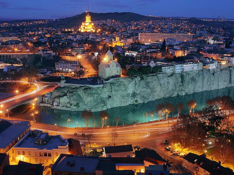
Explore the vibrant sights of Tbilisi on a 5-6 hour Daily Tour. Maximum 25 people. Discover the beauty of Tbilisi City Tour. Contact us to book your spot!
Get In touch
If you would like to request more information, please let us know from the contact page
You will be soon contacted by our staff.
Phones: 995 577 191815, 995 596 191911, 995 599 909020
Tour Info – Price 75 EUROS
Duration: 5-6 Hours
Tbilisi is capital of Georgia. The city stretches along both banks of the Mtkvari River. One of the ancient cities of the world, is more than 1500 years old. King Vakhtang Gorgasali, who reigned in the latter half of the 5th century, started to build it.
Tbilisi was forty times destroyed by the enemies and forty times, it rose from ruins and ashes. It’s a beautiful city with unique historical and architectural monuments. Over 1, million people live on the city’s 350 square kilometers.
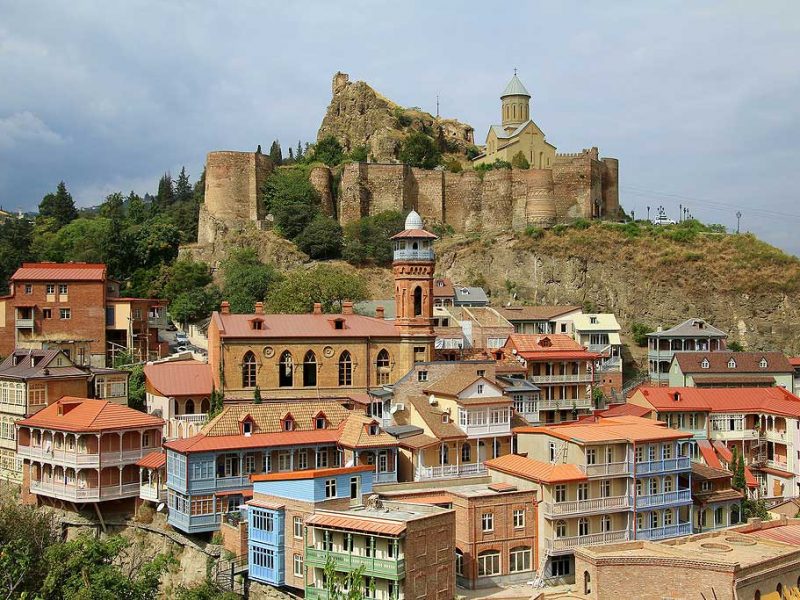
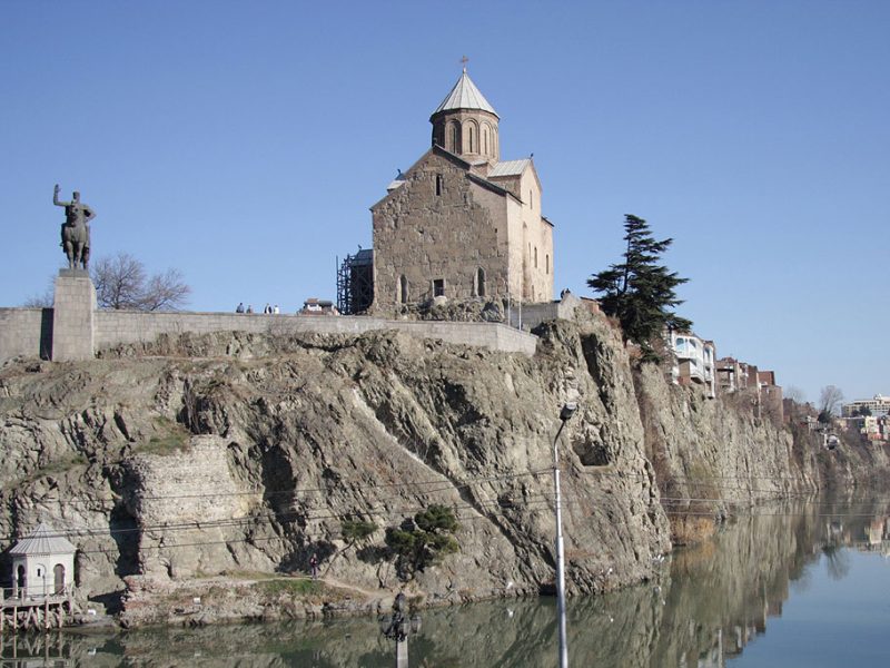
A wonderful panorama of the old city, called old Tbilisi is open from Metekhi. Here stands the 13th century Metekhi church of Virgin. Nearby on a small stone ledge is a monument to Vakhtang Gorgasali, the founder of Tbilisi. On the opposite side are the ruins of the Narikala fortress of the 4th century and mother Georgia colossal statue with a sword in one hand a bowl in the other a symbol of the indomitable spirit of ancient Tbilisi, where enemies were met with hostility and friends with affection. Below the south-west side Narikala are the central Botanical Gardens dating from 1845. Among the oldest architectural monuments are the Anchiskhati church and Sioni cathedral (6th century).
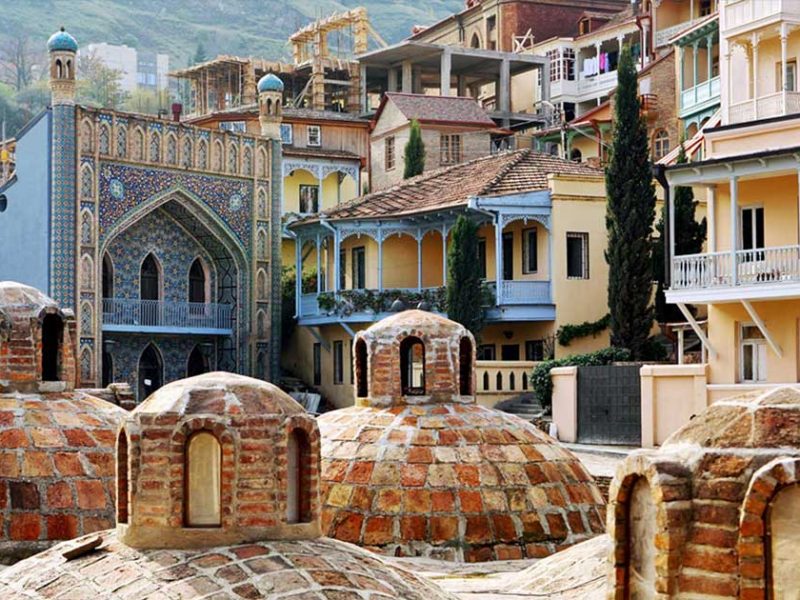
The old Tbilisi has been often raised and rebuilt but has retained the same aspect: the streets are as narrow and winding as they were in medieval times. The courtyards with balconies, the domes of ancient churches, the famous sculptural baths fed by hot springs. Tbilisi main artery is Rustaveli avenue. Most of Government offices, museums, theatres and hotels are in Rustaveli Avenue. There below street level stands Kashueti St. Georgi church built in 1910.
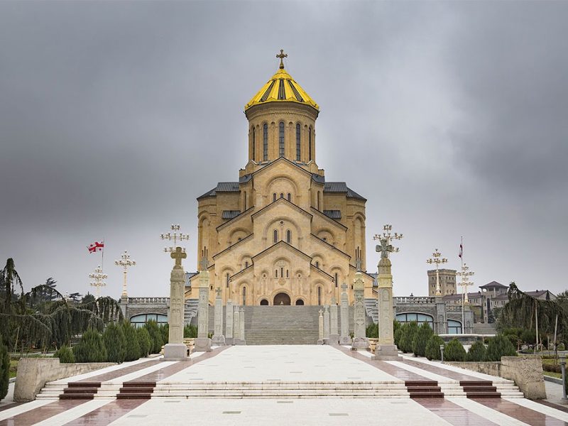
It is impossible to mention all the churches of Tbilisi – 800, 1200, 1400 years old.
The guest are advised to ascend to mount Mtatsminda, one of the symbols of Tbilisi, St. David domed church stand halfway up the slope. Close by there is the pantheon of writers and public figures of Georgia. From mount Mtastminda open a splendid views of both ancient and modern Tbilisi.
Prices and Additional Info:
Tour for two-tree people – 75 euros each person;
Tour for four-seven people – 65 euros each person;
Tour for eight-ten people – 55 euros each person;
Note: 20% discount for children (from 3 to 12 year old) non discount available for two-members tour. Babies are free from tax (from 1 to 2 year old).
Tour can be organised with either Sedan or SUV types of vehicle;
Tour includes: transportation, driver/guide service, cable/train fare, museum ticket and Georgian traditional dinner, home-made wine, vodka or brandy tasting.
Tour Program
1st day - Racha
1. Shaori Lake
Shaori Lake, which is the kargest reservoir in the Racha-Lechkhumi and Lower Svaneti region, is located in the Ambrolauri municipality, on the northern slope of Racha Ridge, Shaori basin. It is kept in place by a barrage dam which ponds Shaori River. The reservoir stretches for 7,1 kilometers from south-west to north-east. Its maximum width is 2,7 kilometers, maximum depth – 14,5 meters, average depth -9,8 meters and it covers an area of 9,2 square kilometers. The water volume is 90,6 million m3. It is nourished by tributaries and precipitation. In the vicinity of Shaori reservoir stands the village of Nikortsminda.
2. Nikortsminda cathedral
Nikortsminda is a domed church in the eponomous village of Ambrolauri municipality, at the end of the 10ty century, after creation of Racha Duchy, the first King of unified feudal Georgia, Bagrat III ordered to lay the foundation for a new temple of St. Nicholas, which would later became the cultural of this duchy.
Nikortsminda church is a masterpiece of Georgian architecture. It was built in the 11th century, in the years 1010-1014. This is the period when great attention was paid to decorative design of facades. It is in this respect that Nikortsminda′s decorations are considered an achievement of Georgian architecture. The dome is preserved in its original form.
3. Sakhinule cave
Similar to Imereti, many karstik caves are in the limestone rocks of Racha. The multi-kilometer depths of the Sakinule cave as well as other caves in Ambrolauri region are well-studed.
4. Accommodation (Khotevi, Ambrolauri)
2nd day - Racha
1. Resort Shovi
The village of Shovi is located in Oni municipality, at the altitude of 1 520 m. It is a climatic-balneological resort of national importance, with a humid climate, with a cold winters (average temperature in January is -60C) and cool summers (average temperature in August is 160C). Medical factors: the mountain climate and mineral water that contains carbon, natrium and calcium. In Shovi there are sanatoriums, rest homes, boarding houses, and tourist bases. The holiday season lasts from June to October.
2. Mountain village Glola (mineral/sour tsklebi)
The village of Glola is situated between two mineral resorts of Racha, Utsera and Shovi. Today, this resorts serve domestic and foreign tourists. This places are truly unique, enclosed by coniferous forests and towered by glaciers and summits covered with snow.
3. Mountain-biking (Katitsvera 3129 m, Satsalike 1996 m)
Racha is mostly covered with forests. Green wood sand coniferous forests follow one another. There are also many mixed forests that are especially spectacular in fall. It is an ideal places for resting because of its forests and temperate climate, summits always covered in snow that’s why you can bike around the mountains.
4. Wine degustation pay free, village Sadmeli (Ambrolauri)
The semisweet wine is made of grapes harvested in the so-called “Khvanchkara Zonule”, in several villages in Ambrolauri region. This local exotic and rare wine has always been regarded as a precious present. If a Rachan peasant hosts you with Khvanchkara, it means that he sacrifices the most precious thing that one can find in Racha to you…
5. Accommodation (Ambrolauri)
3rd day - Lechkhumi
1. Borough Tsageri
Lechkhumi consist mainly of Tsageri and several villages in the vicinity. One may say that this part of the world is situated in a basin of rivers. Tsageri is part of foothills rich in forests and rivers. However, some alpine meadows are included in the territory of the region. The mount of the Tsageri is the most in Lechkhumi and in Georgia as a whole.
2. Mountain Khvamli
Khvamli or khomli is a limestone massif in Racha, located in the western part of Lechkhumi, on the territories of Tskaltubo and Tsageri municipalities, at an altitude of 2002 meters. It presents to the south a bluff 300 meters high. It should be noted that caves of Boga and Tekenteri have entrances stemming from this massif, with the latter located in the hollow of a large beech tree. Khvamli is covered with mixed forests.
From encient historical sourses Khomli Mountain is mention as a place that under order of the Zeus (Jupiter) was arrested Prometheus and circuit on the rock, and then was escaped by Herakles. The above-given sourses confirm that the Khomli Mountain has been the object of interest since the oldest times.
3. The horse riding
The horses in this region are typical Georgian mountain horces. friendly, surefooted easygoing and used to walk long distance. Traditionally the horces are decorated with saddles.
4. Overnight stay in tents.
4th day - Samegrelo
1. Nokalaqevi “Tsikhe-goji”
Nokalakevi, also known by its Greek name Archaepolis (Old Town), and by another Georgian name. tsikhegoji, is a historic fortress in western Georgia, located in Senaki municipality. Currently the village of the same name and an archeological site are situated in the vicinity of the fortress.
The place used to be very important Georgian city in ancient times. According to historical sourses, it was built by Kuji, Duke of Egrisi and Svaneti (3rd century BC).
2. Bandza, Holy Virgin of the Assumption (Martvili)
Holy Virgin of the Assumption is a monument dated to VII century. It is a Georgian monastic complex located in village of Bandza. The monastery was strong cultural and education center. there once stood an ancient and enormous oak tree that was worshipped as an idol of fertility. Infants were once sacrificed here as well. After the conversion of the native population to Cristianity, the ancient tree was cut down so as not to worship it anymore.
3. Tsaishi thermal (mineral) waters in Zugdidi
4. Overnight stay in tents
5th day - Samegrelo-Imereti
1. “Village Gachedili” Canyon (Martvili)
Gachedili is a village in Georgia′s Martvili municipality, in Samegrelo-Zemo Svaneti region. It is located on the Odishi plain, at the right bank of Abasha River, 240 meters above sea level.
Gachedili is famous for its 2 400 meters long, and its depth ranges from 20 to 40 m. There is a 12m high waterfall in the middle of it.
The canyon preserves fossilized bones of animals that lived 75 million years ago, making in the world′s third discovery of a territory abundant in such prehistoric remains. This discovery was made in 2010, by graduate students and masters of the institute of Earth Sciences ofllia State University, during field practice. October 4 of the same year, Gachedili canyon was declared a natural reserve.
2. Okatse Canyon, Kinchkha Waterfall (Khoni)
Okatse Canyon is a natural landmark. It is situated in the gorge of Okatse River, close to Zeda Gorda village, in Khoni municipality.
The length of the river is 14 kilometers, the width of the canyon varies from 3 to 15 meters and the depth from 20 to 100 meters. The canyon is adorned by several affluent waterfalls and the length of one of the lakes, Oskhapo, is 60 meters. There also are several natural stony bridges and caves, from which karstic waters flow.
Okatse Canyon Decorated with cascading waterfalls.
The length of the canyon is 2 kilometers and is still not completely studied.
This is a nice place for traveling, camping and night stay too.
3. Drive to the sea (Kobuleti)
Kobuleti stands in a humid subtropical climate zone. Local winters are often warm and without snow, while summers are quite hot, with frequent downpours. The medium annual temperature of the sea near the coast is 16,70c. kobuleti owes its attractiveness of Kobuleti to its orientation towards the sea, diverse natural environment and striving for endless space. Here, everything is subjected to the moderation and harmonic perception of long streets. Todays Kobuleti is a diamond of the Black Sea coast.
4. Accommodation (Kobuleti)
6th day - Adjara
1. “Village Gachedili” Canyon (Martvili)
Gachedili is a village in Georgia′s Martvili municipality, in Samegrelo-Zemo Svaneti region. It is located on the Odishi plain, at the right bank of Abasha River, 240 meters above sea level.
Gachedili is famous for its 2 400 meters long, and its depth ranges from 20 to 40 m. There is a 12m high waterfall in the middle of it.
The canyon preserves fossilized bones of animals that lived 75 million years ago, making in the world′s third discovery of a territory abundant in such prehistoric remains. This discovery was made in 2010, by graduate students and masters of the institute of Earth Sciences ofllia State University, during field practice. October 4 of the same year, Gachedili canyon was declared a natural reserve.
2. Okatse Canyon, Kinchkha Waterfall (Khoni)
Okatse Canyon is a natural landmark. It is situated in the gorge of Okatse River, close to Zeda Gorda village, in Khoni municipality.
The length of the river is 14 kilometers, the width of the canyon varies from 3 to 15 meters and the depth from 20 to 100 meters. The canyon is adorned by several affluent waterfalls and the length of one of the lakes, Oskhapo, is 60 meters. There also are several natural stony bridges and caves, from which karstic waters flow.
Okatse Canyon Decorated with cascading waterfalls.
The length of the canyon is 2 kilometers and is still not completely studied.
1. Kobuleti
Kobuleti is situated at the Black Sea coast, 5 meters above sea level. The town is a part of Kobuleti Plain.
The climate here is soft subtropical, making Kobuleti one of the most popular balneological resorts in the area. During Soviet times, the town was considered one of the most significant regional resorts. Its popularity grew even more over the last decade. For obvious reasons, it became an alternative to the Abkhazian coastline. Kobuleti hosts over 100 000 tourists every summer.
2. Botanical Garden (Batumi)
Batumi Botanical Garden is located at the Green Cape and covers 275 acres of land close to the sea. The Chakvi settlement was created into the so-called Climatization Garden, which today is known by the name of the Upper Garden.
Today, the garden covers approximately a kilometer of the sea fronts southwestern part, between Chakvistskali river outfall and the Green Cape, and stands at 220 meters above the sea level.
The garden is special due to its diverse and very specific physical and geographical conditions. The collection of plants includes over 5 000 species, types and varieties.
3. Gonio Fortress
At Adjaras Black Sea coast, close to the Chorokhi river outfall, there stands a historic fortress. First records mentioning it belong to a Roman author Gaius Plinius Secundus and date back to 1st century AD. Romans and Greeks called this fortress Apsarunt, the name Gonio originated much later, in the 12th century.
Back in the 2nd century, five Roman military cohorts were located here. By the that time, it was a well-consolidated and comfortable walled town. In 1547-1878, Gonio was under Ottoman occupation. It has one gate on each side and eighteen towers.
4. Kvariati Beach
Kvariati Beach is covered with quite clean sand and pebble. the sea in Kvariati as well as in Sarpi crystal clear. There is a lot of convenient hotels, café and restaurants. there is everything that is necessary for the person for beach rest.
5. Sarpi
The village of Sarpi is located in the Khelvachauri municipality and is built along the shores of Tobashi River. Sarpi is close to the Turkish border and accordingly, there is a checkpoint there. Over the last decade, the touristic infrastructure has developed significantly.
6. Accommodation (Kobuleti)
